
$100.00
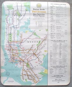
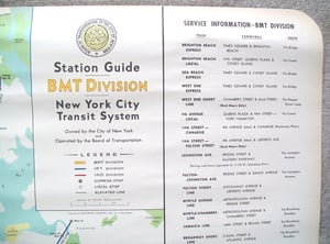
You are bidding on one Near MINT issue of the 1948 New York City Subway Map.
This map was designed and printed by the Hagstrom Map Company of New York.
Maps like this one were mounted inside each subway car.
However, this one was never actually mounted. It was an extra that was stored in a dry place.
This map is 23 inches wide and 28 inches long.
The paper is thick, but not quite card stock.
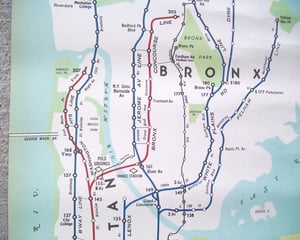
This map has some interesting transit points that no longer exist.
Court Street station in Brooklyn is still on the map, as are Ebbets Field, home of the Brooklyn Dodgers, the Polo Grounds, the Brooklyn Lexington Avenue elevated and the 3rd Avenue elevated. It also mentions transfer points to trolley service. The last trolley operated in New York in 1956.
If you have any questions, please call us at (973) 750-8610, or fill out the contact form. We will be more than happy to answer any and all questions you may have!
This sign would be great for bar or restaurant decoration, dorm room, den, etc. Also makes that one of a kind gift - you can't find this at Sears or Target. Have fun touring old New York. Own a piece of New York history!
Item shipped for free via USPS Priority Mail in the United States. Foreign buyers to pay actual shipping charges.